Episode #29d- Bonnie Scotland Tour Day 5 : The Orkney Islands
Today was an especially long tour day, leaving the hotel at 8:45 a.m. and not returning until 6:30. Our bus took us to the pedestrian ferry at John O’Groats at the northeastern tip of Scotland in order to cross the Pentland Firth to South Ronaldsay. By using the Churchill Causeway, the tour bus that met us at the ferry was able to take us onto Burray and the East and West Mainland islands to see all the major sites.
The Orkneys are home to just over 22,000 people, 100,000 cattle and about 120,000 sheep. At a latitude of 59 degrees, they are even with Juneau Alaska and Hudson’s Bay, but are much more temperate due to their nearness to the Gulf Stream.
The WIND, on the other hand, can be crazy. In January of 1952 a storm with winds of up to 120 mph (200 kph) effectively wiped out the chicken farming industry in the islands. Our guide John joked that the hens arrived in Norway as feather dusters!
Honestly, I’m just too tired to be as chatty as usual today, and a late dinner with entertainment by Scottish dancers beckons. I hope you’ll enjoy sharing our day in pictures with captions.
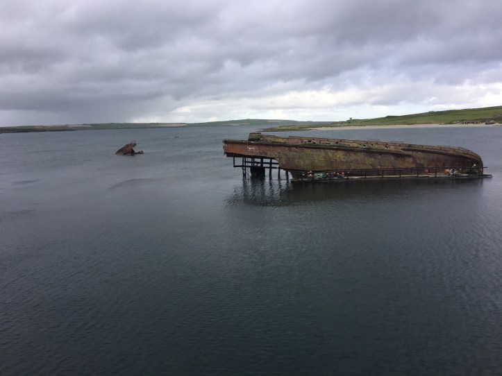
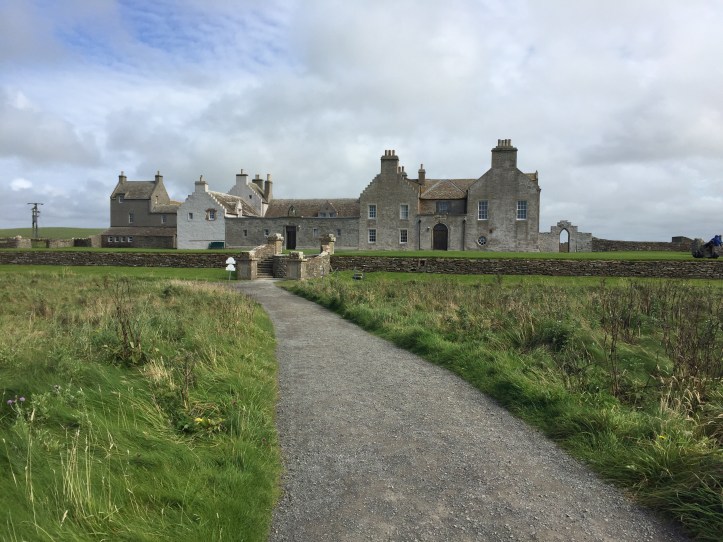
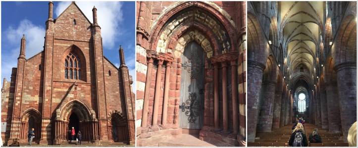
Walter Mowat greeted us at his shop “First & Last” at the ferry dock, where we were able to send postcards that will be postmarked John O’Groats. The town was named after Dutch sailor Jan de Groot, who settled here and built his unique octagonal house.During WWII the British attempted to block the sea passage through the Orkneys with “block ships”, sunk to impede traffic. Some of those hulls still protrude from the water. The Churchill Barrier was later erected as a better way to keep German boats out of Britain, and now form the basis of the causeway connecting the three islands we toured. The barrier is made of 5 and 10 ton cement blocks, many made by Italian POW’s held in the Orkneys. There are more ships creating navigational challenges in the area: in the natural harbour Scappa Flow, in the southern part of the Orkneys, 74 German warships were scuttled; although some have been pulled out and scrapped, it is still an area where divers can explore many wrecks.At the site of WWII POW camp 60 on Lamb Holm we visited the Italian Chapel, built by Italian POWs out of 2 Nissen Huts and scavenged materials. Although portions of the chapel look like tile, marble, wrought iron and plasterwork, it is actually all painted effects on plasterboard, cement-covered scrap hardware(the font)and even empty bully beef tins (the lanterns in the nave). One of the prisoners, Domenico Chiocchetti, stayed behind after the war to finish painting it. The statue now outside the chapel, commemorating the POWs, is made of concrete and fencing wire.Located about 6 miles north of Stromness on the Mainland (the largest Orkney island) the Ring of Brodgar is known as “the Scottish Stonehenge”. Thirty-seven of the original 60 stones are still standing. This ring was built in the neolithic period 4000-4500 years ago, probably not long after Stenness (no photo, but we drove past the 3 stones that remain there of its original 12). Nearby is an ongoing archeological dig of a settlement called the Ness of Brodgar, as well as 9 Bronze Age (800-1000 years newer than the ring) burial mounds, each containing the cremated remains of a single person, in a stone box.Skara Brae is a stone age village of 8 clustered houses occupied from about 3000 BC to about 2500 BC and is Europe’s most complete Neolithic village. It was first uncovered in 1850 after a severe storm severely damaged the coastline around the Bay of Skaill and exposed the rock houses. The houses contain central hearths as well as stone beds, dressers and tables – think The Flintstones cartoon – only real!!Skaill House is the 17th century home of the Laird of Breckness, on whose land Skara Brae was uncovered.In Kirkwall, the capital of the Orkneys, we visited St Magnus Cathedral, a Romanesque and Norman style cathedral built over a span of about 300 years beginning in 1137 AD.The remains of canonized Magnus – originally kept in the smaller Kirk of St Olaf are interred in one of the pillars. This church is also the location of the impressive tomb of John Rae, the man who discovered the fate of the Franklin Expedition.
That was today! After a slightly choppy ferry ride back to John o’Groats, we returned to our hotel in Caithness for a demonstration of Scottish dance and a rich venison stew dinner.